Trail Cycle Condé-sur-l'Escaut - étang  Chabaud Latour - Photo
© OpenStreetMap contributors
Length
Length
8.7 km
Max alt
Max alt
25 m
Uphill gradient
Uphill gradient
51 m
Km-Effort
Km-Effort  
9.4 km
Min alt
Min alt
12 m
Downhill gradient
Downhill gradient
51 m
Boucle
Boucle
Yes
Creation date :
2014-12-10 00:00:00.0
Updated on :
2014-12-10 00:00:00.0

(0 Reviews)

Cycle
Cycle
1h14
Difficulty : Easy

Scan this QR Code to open this trail in the SityTrail application

FREE GPS app for hiking

Logo SityTrail SityTrail

IGN / Geographical institutes

Download SityTrail from the App Store Download SityTrail from Google Play

Logo SityTrail SityTrail World

The world is yours!

Download SityTrail from the App Store Download SityTrail from Google Play Download SityTrail on Huawei AppGallery

About

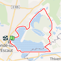
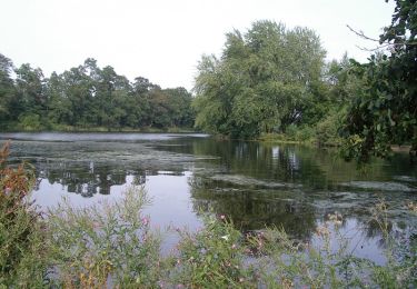
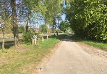
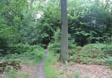
Trail Cycle of 8.7 km to be discovered at Hauts-de-France, Nord, Condé-sur-l'Escaut. This trail is proposed by Obeone2264.

Description

Départ du parking à côté grande surface.

Elevation profile

Photos

Points of interest

Point of interest Condé-sur-l'Escaut - Canalisations - Photo
Obeone2264
CONDÉ-SUR-L'ESCAUT 
Point of interest Condé-sur-l'Escaut - chasse  aux canards - Photo
Obeone2264
CONDÉ-SUR-L'ESCAUT 
Point of interest Condé-sur-l'Escaut - le relais des moulineaux - Photo
Obeone2264
CONDÉ-SUR-L'ESCAUT 
Point of interest Condé-sur-l'Escaut - chevalement de mine  - Photo
Obeone2264
CONDÉ-SUR-L'ESCAUT 
Point of interest Condé-sur-l'Escaut - vue de l'étang  - Photo
Obeone2264
CONDÉ-SUR-L'ESCAUT 

Positioning

Country:
France
Region :
Hauts-de-France
Department/Province :
Nord
Municipality :
Condé-sur-l'Escaut
Location:
Unknown
Start:(UTM)
542054 ; 5589249 (31U) N.

Trails nearby

Trail Walking Bernissart - Bon-Secours - Circuit Natura 2000, des sites qui valent le détour - Ht07 - Photo
Walking
GUIDE+

Walking

Easy
(3)
Bernissart, Wallonia, Hainaut, Belgium
6 km | 7.1 km-effort
1h 37min
Yes
Trail Walking Péruwelz - Bon Secours à Condé sur Escaut  - Photo
Walking
Morelli

Walking

Medium
(1)
Péruwelz, Wallonia, Hainaut, Belgium
25 km | 27 km-effort
4h 11min
Yes
Trail Walking Fresnes-sur-Escaut - Circuit du Cavalier - Somain Péruwelz  - Fresnes sur Escaut - Photo
Walking
tracegps

Walking

Easy
(2)
Fresnes-sur-Escaut, Hauts-de-France, Nord, France
6.5 km | 7.1 km-effort
1h 40min
Yes
Trail Walking Hergnies - Entre terre et eaux - Hergnies - Photo
Walking
tracegps

Walking

Difficult
(1)
Hergnies, Hauts-de-France, Nord, France
13.2 km | 13.9 km-effort
3h 19min
Yes
Trail Walking Condé-sur-l'Escaut - Circuit des remparts de Condé  -  Condé sur l'Escaut - Photo
Walking
tracegps

Walking

Easy
(1)
Condé-sur-l'Escaut, Hauts-de-France, Nord, France
4.6 km | 5.1 km-effort
1h 10min
Yes
Trail Walking Condé-sur-l'Escaut - Circuit de la Canarderie  -  Condé sur l'Escaut - Photo
Walking
tracegps

Walking

Medium
(1)
Condé-sur-l'Escaut, Hauts-de-France, Nord, France
9.8 km | 10.6 km-effort
2h 30min
Yes
Trail Walking Péruwelz - bois Bonsecours - Photo
Walking
doclocjl

Walking

Easy
(1)
Péruwelz, Wallonia, Hainaut, Belgium
7.8 km | 8.9 km-effort
2h 17min
Yes
Trail Equestrian Péruwelz - Cross-border loop of Bon-Secours - Photo
Equestrian
GUIDE+

Equestrian

Very easy
Péruwelz, Wallonia, Hainaut, Belgium
11.6 km | 13.2 km-effort
Unknown
Yes
Trail On foot Péruwelz - Marshal Croÿ circuit - Photo
On foot
GUIDE+

On foot

Easy
(1)
Péruwelz, Wallonia, Hainaut, Belgium
4.2 km | 5 km-effort
1h 8min
Yes


Close
My subscriptions