Trail Mountain bike Saint-Rémy-lès-Chevreuse - La Jean Racine 2012 - 80 km - Photo
 tracegps
tracegps

User

© OpenStreetMap contributors
Length
Length
74 km
Max alt
Max alt
184 m
Uphill gradient
Uphill gradient
1616 m
Km-Effort
Km-Effort  
96 km
Min alt
Min alt
73 m
Downhill gradient
Downhill gradient
1624 m
Boucle
Boucle
No
Creation date :
2014-12-10 00:00:00.0
Updated on :
2014-12-10 00:00:00.0

(0 Reviews)

Mountain bike
Mountain bike
7h00
Difficulty : Very difficult

Scan this QR Code to open this trail in the SityTrail application

FREE GPS app for hiking

Logo SityTrail SityTrail

IGN / Geographical institutes

Download SityTrail from the App Store Download SityTrail from Google Play

Logo SityTrail SityTrail World

The world is yours!

Download SityTrail from the App Store Download SityTrail from Google Play Download SityTrail on Huawei AppGallery

About

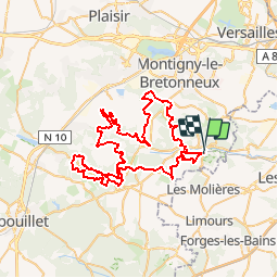
Trail Mountain bike of 74 km to be discovered at Ile-de-France, Yvelines, Saint-Rémy-lès-Chevreuse. This trail is proposed by tracegps.

Description

Raid dans le cadre de La Jean Racine 2012, circuit pour vététistes confirmés, n'hésitez pas à descendre de monture pour les parties trop techniques. Circuit à faire suite à du temps sec. Attention, il y a peut-être des portions sur des propriétés privées alors contournez-les si nécessaire !

Elevation profile

Photos

Positioning

Country:
France
Region :
Ile-de-France
Department/Province :
Yvelines
Municipality :
Saint-Rémy-lès-Chevreuse
Location:
Unknown
Start:(UTM)
431463 ; 5394802 (31U) N.

Trails nearby

Trail Walking Saint-Rémy-lès-Chevreuse - _Entre vallées et châteaux - Photo
Walking
GUIDE+

Walking

Medium
(13)
Saint-Rémy-lès-Chevreuse, Ile-de-France, Yvelines, France
7.8 km | 9.6 km-effort
2h 0min
Yes
Trail Walking Chevreuse - _La balade de tous les plaisirs - Photo
Walking
GUIDE+

Walking

Easy
(8)
Chevreuse, Ile-de-France, Yvelines, France
5.5 km | 7 km-effort
1h 30min
Yes
Trail Walking Chevreuse - _Sur les pas de Racine (première partie) - Photo
Walking
GUIDE+

Walking

Easy
(7)
Chevreuse, Ile-de-France, Yvelines, France
10.7 km | 14.5 km-effort
2h 30min
Yes
Trail Walking Choisel - _Si Choisel m'était conté - Photo
Walking
GUIDE+

Walking

Easy
(8)
Choisel, Ile-de-France, Yvelines, France
5.6 km | 6.6 km-effort
1h 27min
Yes
Trail Walking Gif-sur-Yvette - _Gif sur Yvette, une ville à la campagne - Photo
Walking
GUIDE+

Walking

Medium
(3)
Gif-sur-Yvette, Ile-de-France, Essonne, France
8.6 km | 10.5 km-effort
2h 0min
Yes
Trail Walking Magny-les-Hameaux - _La Vallée de la Mérantaise - Photo
Walking
GUIDE+

Walking

Easy
(5)
Magny-les-Hameaux, Ile-de-France, Yvelines, France
9.7 km | 11.6 km-effort
2h 30min
Yes
Trail Walking Saint-Lambert - _Sur les pas de Racine (deuxième partie) - Photo
Walking
GUIDE+

Walking

Easy
(2)
Saint-Lambert, Ile-de-France, Yvelines, France
10.5 km | 12.5 km-effort
2h 30min
Yes
Trail Walking Châteaufort - gitane à  Chateaufort  - Photo
Walking
philou91

Walking

Easy
(1)
Châteaufort, Ile-de-France, Yvelines, France
6.4 km | 7.7 km-effort
2h 3min
Yes
Trail Walking Milon-la-Chapelle - Yvelines_Milon-La-Chapelle=>Chemins_Beauregard&Jean-Racine=>Chevreuse - Photo
Walking
BMorin91470

Walking

Easy
(1)
Milon-la-Chapelle, Ile-de-France, Yvelines, France
9.3 km | 12.7 km-effort
1h 56min
Yes


Close
My subscriptions