Trail Walking Orleix - Dans les bois d'Orleix - Le Bois Sibat - Photo

Dans les bois d'Orleix - Le Bois Sibat

 tracegps
tracegps

User

© OpenStreetMap contributors
Length
Length
13.6 km
Max alt
Max alt
379 m
Uphill gradient
Uphill gradient
250 m
Km-Effort
Km-Effort  
16.9 km
Min alt
Min alt
273 m
Downhill gradient
Downhill gradient
250 m
Boucle
Boucle
Yes
Creation date :
2014-12-10 00:00:00.0
Updated on :
2014-12-10 00:00:00.0

(0 Reviews)

Walking
Walking
2h00
Difficulty : Medium

Scan this QR Code to open this trail in the SityTrail application

FREE GPS app for hiking

Logo SityTrail SityTrail

IGN / Geographical institutes

Download SityTrail from the App Store Download SityTrail from Google Play

Logo SityTrail SityTrail World

The world is yours!

Download SityTrail from the App Store Download SityTrail from Google Play Download SityTrail on Huawei AppGallery

About

Trail Walking of 13.6 km to be discovered at Occitania, Hautespyrenees, Orleix. This trail is proposed by tracegps.

Description

Boucle dans les coteaux d'Orleix avec la Tour d'Oléac-Debat comme point culminant.

Elevation profile

Photos

Positioning

Country:
France
Region :
Occitania
Department/Province :
Hautespyrenees
Municipality :
Orleix
Location:
Unknown
Start:(UTM)
264899 ; 4794379 (31T) N.

Trails nearby

Trail On foot Tarbes - Le Chemin Vert - Photo
On foot
PRO

On foot

Medium
Tarbes, Occitania, Hautespyrenees, France
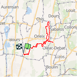
18.6 km | 22 km-effort
4h 54min
No
Trail Running Orleix - Dans les bois d'Orleix - Le Bois Sibat - Photo
Running
tracegps

Running

Medium
Orleix, Occitania, Hautespyrenees, France
13.6 km | 16.9 km-effort
1h 30min
Yes
Trail Mountain bike Orleix - Dans les bois d'Orleix - Le Bois Sibat - Photo
Mountain bike
tracegps

Mountain bike

Medium
Orleix, Occitania, Hautespyrenees, France
13.6 km | 16.9 km-effort
45min
Yes
Trail Walking Tarbes - Le Chemin Vert - Photo
Walking
chasle

Walking

Easy
Tarbes, Occitania, Hautespyrenees, France
17.2 km | 20 km-effort
4h 35min
No
Trail Road bike Tarbes - caminadour velo - Photo
Road bike
LouisROGER

Road bike

Easy
Tarbes, Occitania, Hautespyrenees, France
14.2 km | 15.2 km-effort
5h 5min
No
Trail Cycle Tarbes - vélo ecole de Ger 2022 caminadour du collège au nord du lac de Bours - Photo
Cycle
LouisROGER

Cycle

Very easy
Tarbes, Occitania, Hautespyrenees, France
15.1 km | 16.3 km-effort
Unknown
Yes
Trail Nordic walking Aureilhan - MN-10-Caminadour - Photo
Nordic walking
cromignon

Nordic walking

Very easy
Aureilhan, Occitania, Hautespyrenees, France
10.1 km | 10.9 km-effort
1h 50min
Yes
Trail Walking Bours - les Rives de l'Adour  - Photo
Walking
embarbe

Walking

Easy
Bours, Occitania, Hautespyrenees, France
10.1 km | 10.8 km-effort
2h 19min
Yes
Trail Mountain bike Tarbes - Tarbes et bois du commandeur - Photo
Mountain bike
viga

Mountain bike

Easy
Tarbes, Occitania, Hautespyrenees, France
35 km | 39 km-effort
2h 35min
Yes


Close
My subscriptions