Trail Cycle Montbozon - Boucle de l'Avant Doubs - Montbozon  - Photo

Boucle de l'Avant Doubs - Montbozon

 tracegps
tracegps

User

© OpenStreetMap contributors
Length
Length
32 km
Max alt
Max alt
306 m
Uphill gradient
Uphill gradient
413 m
Km-Effort
Km-Effort  
37 km
Min alt
Min alt
232 m
Downhill gradient
Downhill gradient
413 m
Boucle
Boucle
Yes
Creation date :
2014-12-10 00:00:00.0
Updated on :
2014-12-10 00:00:00.0

(0 Reviews)

Cycle
Cycle
1h30
Difficulty : Medium

Scan this QR Code to open this trail in the SityTrail application

FREE GPS app for hiking

Logo SityTrail SityTrail

IGN / Geographical institutes

Download SityTrail from the App Store Download SityTrail from Google Play

Logo SityTrail SityTrail World

The world is yours!

Download SityTrail from the App Store Download SityTrail from Google Play Download SityTrail on Huawei AppGallery

About

Trail Cycle of 32 km to be discovered at Bourgogne-Franche-Comté, Haute-Saône, Montbozon. This trail is proposed by tracegps.

Description

Circuit proposé par l'Office de Tourisme des 7 rivières et et le Conseil général de la Haute-Saône. Départ de Montbozon. Retrouvez le circuit sur le site du Conseil général de la Haute-Saône.

Elevation profile

Photos

Positioning

Country:
France
Region :
Bourgogne-Franche-Comté
Department/Province :
Haute-Saône
Municipality :
Montbozon
Location:
Unknown
Start:(UTM)
293439 ; 5260656 (32T) N.

Trails nearby

Trail Walking Montbozon - Montbozon 18 mars 2021  IBP 61  - Photo
Walking
TRIMAILLE

Walking

Medium
Montbozon, Bourgogne-Franche-Comté, Haute-Saône, France
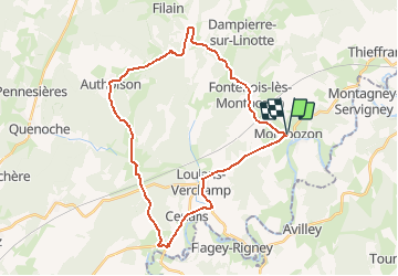
23 km | 28 km-effort
5h 57min
Yes
Trail Walking Montbozon - La goutte d'eau - Montbozon - Photo
Walking
tracegps

Walking

Easy
(1)
Montbozon, Bourgogne-Franche-Comté, Haute-Saône, France
4.5 km | 5.6 km-effort
1h 10min
Yes
Trail Walking Dampierre-sur-Linotte - Dampierre sur Linotte - Photo
Walking
legios84

Walking

Medium
Dampierre-sur-Linotte, Bourgogne-Franche-Comté, Haute-Saône, France
18.1 km | 22 km-effort
4h 13min
Yes
Trail Walking Vy-lès-Filain - Vy lès Filain- Maizières - Photo
Walking
dagobert5612

Walking

Very easy
Vy-lès-Filain, Bourgogne-Franche-Comté, Haute-Saône, France
22 km | 28 km-effort
6h 53min
No
Trail Bicycle tourism Montbozon - 39 Besançon entre Saône & Doubs J 4/6 - Photo
Bicycle tourism
ericf64

Bicycle tourism

Medium
Montbozon, Bourgogne-Franche-Comté, Haute-Saône, France
55 km | 64 km-effort
6h 10min
No
Trail Walking Montbozon - SityTrail - Montbozon Dampierre-sur-Linotte - Photo
Walking
gerardmicheline

Walking

Very difficult
Montbozon, Bourgogne-Franche-Comté, Haute-Saône, France
22 km | 27 km-effort
6h 10min
Yes
Trail Walking Thiénans - Tour de thienans - Photo
Walking
JJPGP

Walking

Easy
Thiénans, Bourgogne-Franche-Comté, Haute-Saône, France
1.5 km | 1.9 km-effort
28min
Yes
Trail Walking Thiénans - Rando cimetiere - Photo
Walking
JJPGP

Walking

Easy
Thiénans, Bourgogne-Franche-Comté, Haute-Saône, France
2.8 km | 3.4 km-effort
1h 18min
No
Trail sport Montbozon - Montbozon Dampierre-sur-Linotte - Photo
sport
gerardmicheline

sport

Very easy
Montbozon, Bourgogne-Franche-Comté, Haute-Saône, France
20 km | 26 km-effort
Unknown
Yes


Close
My subscriptions