Trail Walking Flêtre - Sentier du Bois Greffier - Flêtre - Photo

Sentier du Bois Greffier - Flêtre

 tracegps
tracegps

User

© OpenStreetMap contributors
Length
Length
11.5 km
Max alt
Max alt
89 m
Uphill gradient
Uphill gradient
133 m
Km-Effort
Km-Effort  
13.2 km
Min alt
Min alt
36 m
Downhill gradient
Downhill gradient
133 m
Boucle
Boucle
Yes
Creation date :
2014-12-10 00:00:00.0
Updated on :
2014-12-10 00:00:00.0

(0 Reviews)

Walking
Walking
2h55
Difficulty : Medium

Scan this QR Code to open this trail in the SityTrail application

FREE GPS app for hiking

Logo SityTrail SityTrail

IGN / Geographical institutes

Download SityTrail from the App Store Download SityTrail from Google Play

Logo SityTrail SityTrail World

The world is yours!

Download SityTrail from the App Store Download SityTrail from Google Play Download SityTrail on Huawei AppGallery

About

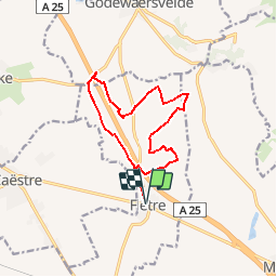
Trail Walking of 11.5 km to be discovered at Hauts-de-France, Nord, Flêtre. This trail is proposed by tracegps.

Description

Circuit proposé par le comité départemental du Tourisme du Nord. Départ de l'église de Flêtre. Pour randonneurs avertis, ce circuit au pied du Mont des Cats chemine sur de petites routes de campagne et des sentiers forestiers ou agricoles. La meilleure période s’étale d’avril à octobre. Retrouvez cette randonnée sur le site du comité départemental du Tourisme du Nord.

Elevation profile

Photos

Positioning

Country:
France
Region :
Hauts-de-France
Department/Province :
Nord
Municipality :
Flêtre
Location:
Unknown
Start:(UTM)
474980 ; 5622506 (31U) N.

Trails nearby

Trail Walking Eecke - Circuit du Klockhuis (Grande boucle) - Eecke - Photo
Walking
tracegps

Walking

Difficult
(2)
Eecke, Hauts-de-France, Nord, France
15 km | 16.5 km-effort
3h 45min
Yes
Trail Walking Berthen - Autour du monastère - Godewaersvelde - Photo
Walking
tracegps

Walking

Difficult
(3)
Berthen, Hauts-de-France, Nord, France
11.8 km | 15.6 km-effort
3h 0min
Yes
Trail Walking Boeschepe - Boeschepe - Photo
Walking
fif59280

Walking

Difficult
Boeschepe, Hauts-de-France, Nord, France
10.6 km | 13 km-effort
2h 26min
No
Trail Walking Boeschepe - Monts des Flandres CAF LILLE week-end des estaminets 2 - Photo
Walking
reneperrin

Walking

Easy
Boeschepe, Hauts-de-France, Nord, France
21 km | 26 km-effort
5h 34min
Yes
Trail Walking Boeschepe - Week-end des estaminets CAF1 - Photo
Walking
reneperrin

Walking

Easy
Boeschepe, Hauts-de-France, Nord, France
16.7 km | 21 km-effort
4h 32min
Yes
Trail Walking Berthen - Balade des Katts - Photo
Walking

Walking

Very easy
(3)
Berthen, Hauts-de-France, Nord, France
4.8 km | 6.4 km-effort
Unknown
Yes
Trail Running Berthen - mont des cats - Photo
Running
jamboxland

Running

Medium
Berthen, Hauts-de-France, Nord, France
11 km | 14.5 km-effort
1h 10min
Yes
Trail Walking Eecke - Circuit du Klockhuis (Petite boucle) - Eecke - Photo
Walking
tracegps

Walking

Medium
Eecke, Hauts-de-France, Nord, France
10.2 km | 11.7 km-effort
2h 30min
Yes
Trail Walking Berthen - Sentier de Berthen - Photo
Walking
tracegps

Walking

Medium
(1)
Berthen, Hauts-de-France, Nord, France
7.6 km | 9.7 km-effort
2h 0min
Yes


Close
My subscriptions