


Riez

fpitance
User
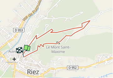

Length
2 km

Max alt
641 m

Uphill gradient
101 m
Km-Effort
3.3 km

Min alt
537 m

Downhill gradient
96 m
Boucle
Yes
Creation date :
2014-12-10 00:00:00.0
Updated on :
2014-12-10 00:00:00.0
--
Difficulty : Easy

FREE GPS app for hiking
 SityTrail
IGN / Geographical institutes
SityTrail Plus
The world is yours!
About
Trail Walking of 2 km to be discovered at Provence-Alpes-Côte d'Azur, Alpes-de-Haute-Provence, Riez. This trail is proposed by fpitance.
Description
Pres de la chapelle St Maxime
Positioning
Country:
France
Region :
Provence-Alpes-Côte d'Azur
Department/Province :
Alpes-de-Haute-Provence
Municipality :
Riez
Location:
Unknown
Start:(Dec)
Start:(UTM)
266116 ; 4855923 (32T) N.
Comments