


col de St jur

fpitance
User
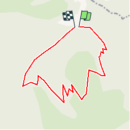

Length
4.5 km

Max alt
1514 m

Uphill gradient
335 m
Km-Effort
9 km

Min alt
1165 m

Downhill gradient
342 m
Boucle
Yes
Creation date :
2014-12-10 00:00:00.0
Updated on :
2014-12-10 00:00:00.0
--
Difficulty : Easy

FREE GPS app for hiking
 SityTrail
IGN / Geographical institutes
SityTrail Plus
The world is yours!
About
Trail Walking of 4.5 km to be discovered at Provence-Alpes-Côte d'Azur, Alpes-de-Haute-Provence, Saint-Jurs. This trail is proposed by fpitance.
Description
L'agra
Positioning
Country:
France
Region :
Provence-Alpes-Côte d'Azur
Department/Province :
Alpes-de-Haute-Provence
Municipality :
Saint-Jurs
Location:
Unknown
Start:(Dec)
Start:(UTM)
277914 ; 4865547 (32T) N.
Comments