


étang de la loge

dedicace
User
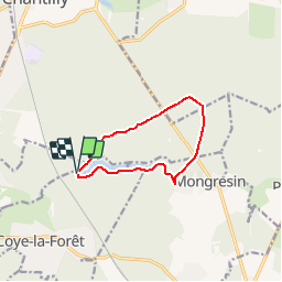

Length
8.5 km

Max alt
74 m

Uphill gradient
74 m
Km-Effort
9.5 km

Min alt
45 m

Downhill gradient
81 m
Boucle
Yes
Creation date :
2014-12-10 00:00:00.0
Updated on :
2014-12-10 00:00:00.0
3h00
Difficulty : Easy

FREE GPS app for hiking
 SityTrail
IGN / Geographical institutes
SityTrail Plus
The world is yours!
About
Trail Walking of 8.5 km to be discovered at Hauts-de-France, Oise, Coye-la-Forêt. This trail is proposed by dedicace.
Description
Départ cht de la Reine blanche, tble de Mongrésin, étg Chapron, retour Cht de la Reine Blanche
Positioning
Country:
France
Region :
Hauts-de-France
Department/Province :
Oise
Municipality :
Coye-la-Forêt
Location:
Unknown
Start:(Dec)
Start:(UTM)
462020 ; 5444973 (31U) N.
Comments
look super