


Englishberg

Claudele
User
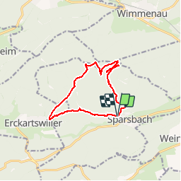

Length
12.5 km

Max alt
382 m

Uphill gradient
265 m
Km-Effort
16 km

Min alt
215 m

Downhill gradient
266 m
Boucle
Yes
Creation date :
2014-12-10 00:00:00.0
Updated on :
2019-05-12 18:17:52.704
4h49
Difficulty : Very easy

FREE GPS app for hiking
 SityTrail
IGN / Geographical institutes
SityTrail Plus
The world is yours!
About
Trail Walking of 12.5 km to be discovered at Grand Est, Bas-Rhin, Sparsbach. This trail is proposed by Claudele.
Positioning
Country:
France
Region :
Grand Est
Department/Province :
Bas-Rhin
Municipality :
Sparsbach
Location:
Unknown
Start:(Dec)
Start:(UTM)
383325 ; 5415200 (32U) N.
Comments