


ParisPruinesJ5

jybouteyre
User
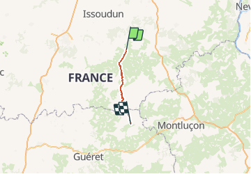

Length
52 km

Max alt
498 m

Uphill gradient
747 m
Km-Effort
61 km

Min alt
161 m

Downhill gradient
531 m
Boucle
No
Creation date :
2014-12-10 00:00:00.0
Updated on :
2014-12-10 00:00:00.0
--
Difficulty : Unknown

FREE GPS app for hiking
 SityTrail
IGN / Geographical institutes
SityTrail Plus
The world is yours!
About
Trail Running of 52 km to be discovered at Centre-Loire Valley, Cher, Lignières. This trail is proposed by jybouteyre.
Positioning
Country:
France
Region :
Centre-Loire Valley
Department/Province :
Cher
Municipality :
Lignières
Location:
Unknown
Start:(Dec)
Start:(UTM)
437151 ; 5177915 (31T) N.
Comments