


davenucours

lefrancm
User

Length
16.5 km

Max alt
114 m

Uphill gradient
222 m
Km-Effort
19.5 km

Min alt
43 m

Downhill gradient
227 m
Boucle
Yes
Creation date :
2014-12-10 00:00:00.0
Updated on :
2014-12-10 00:00:00.0
3h34
Difficulty : Unknown

FREE GPS app for hiking
 SityTrail
IGN / Geographical institutes
SityTrail Plus
The world is yours!
About
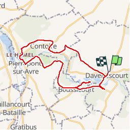
Trail Walking of 16.5 km to be discovered at Hauts-de-France, Somme, Davenescourt. This trail is proposed by lefrancm.
Positioning
Country:
France
Region :
Hauts-de-France
Department/Province :
Somme
Municipality :
Davenescourt
Location:
Unknown
Start:(Dec)
Start:(UTM)
471082 ; 5506577 (31U) N.
Comments