


randonnée avec decize

kronio
User
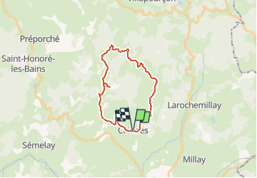

Length
24 km

Max alt
519 m

Uphill gradient
594 m
Km-Effort
32 km

Min alt
287 m

Downhill gradient
585 m
Boucle
Yes
Creation date :
2014-12-10 00:00:00.0
Updated on :
2014-12-10 00:00:00.0
5h33
Difficulty : Unknown

FREE GPS app for hiking
 SityTrail
IGN / Geographical institutes
SityTrail Plus
The world is yours!
About
Trail Walking of 24 km to be discovered at Bourgogne-Franche-Comté, Nièvre, Chiddes. This trail is proposed by kronio.
Description
Randonnée
Positioning
Country:
France
Region :
Bourgogne-Franche-Comté
Department/Province :
Nièvre
Municipality :
Chiddes
Location:
Unknown
Start:(Dec)
Start:(UTM)
571832 ; 5190052 (31T) N.
Comments
sympa mais trop de route sur la fin