


le col de riou

cemoi
User
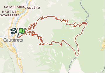

Length
16.5 km

Max alt
2160 m

Uphill gradient
1219 m
Km-Effort
33 km

Min alt
948 m

Downhill gradient
1219 m
Boucle
Yes
Creation date :
2019-06-18 08:27:00.634
Updated on :
2020-04-24 08:02:54.036
--
Difficulty : Difficult

FREE GPS app for hiking
 SityTrail
IGN / Geographical institutes
SityTrail Plus
The world is yours!
About
Trail Walking of 16.5 km to be discovered at Occitania, Hautespyrenees, Cauterets. This trail is proposed by cemoi.


Positioning
Country:
France
Region :
Occitania
Department/Province :
Hautespyrenees
Municipality :
Cauterets
Location:
Unknown
Start:(Dec)
Start:(UTM)
735847 ; 4752688 (30T) N.
Comments