


autour d'argeles

harydh
User GUIDE
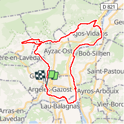

Length
20 km

Max alt
646 m

Uphill gradient
457 m
Km-Effort
26 km

Min alt
396 m

Downhill gradient
459 m
Boucle
Yes
Creation date :
2014-12-10 00:00:00.0
Updated on :
2014-12-10 00:00:00.0
--
Difficulty : Easy

FREE GPS app for hiking
 SityTrail
IGN / Geographical institutes
SityTrail Plus
The world is yours!
About
Trail Mountain bike of 20 km to be discovered at Occitania, Hautespyrenees, Argelès-Gazost. This trail is proposed by harydh.
Description
bucolique ,varié et apaisant


Positioning
Country:
France
Region :
Occitania
Department/Province :
Hautespyrenees
Municipality :
Argelès-Gazost
Location:
Unknown
Start:(Dec)
Start:(UTM)
736206 ; 4765641 (30T) N.
Comments