


ceuse9 avril 2012

harydh
User GUIDE
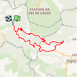

Length
18.1 km

Max alt
1659 m

Uphill gradient
558 m
Km-Effort
26 km

Min alt
1226 m

Downhill gradient
558 m
Boucle
Yes
Creation date :
2014-12-10 00:00:00.0
Updated on :
2014-12-10 00:00:00.0
--
Difficulty : Medium

FREE GPS app for hiking
 SityTrail
IGN / Geographical institutes
SityTrail Plus
The world is yours!
About
Trail Mountain bike of 18.1 km to be discovered at Provence-Alpes-Côte d'Azur, Hautes-Alpes, Châteauneuf-d'Oze. This trail is proposed by harydh.
Description
magnifique
Positioning
Country:
France
Region :
Provence-Alpes-Côte d'Azur
Department/Province :
Hautes-Alpes
Municipality :
Châteauneuf-d'Oze
Location:
Unknown
Start:(Dec)
Start:(UTM)
731043 ; 4932222 (31T) N.
Comments
bou noel 2014