


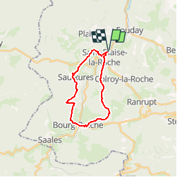
Saint-Blaise-la-Roche

VacheKiri67
User


5h15
Difficulty : Medium

FREE GPS app for hiking
 SityTrail
IGN / Geographical institutes
SityTrail Plus
The world is yours!
About
Trail Walking of 17.4 km to be discovered at Grand Est, Bas-Rhin, Saint-Blaise-la-Roche. This trail is proposed by VacheKiri67.
Description
Balisage : croix jaune - triangle bleu - rectangle jaune - croix rouge.
Faite le 17/06/2012 en 5h15 (dont 0h35 de pause) avec notre fils de 7 ans.
Plus de détails :
Passion Vosges - La Haute-Bruche N°27 Page 95
Les rives de la Bruche, contrée de passages et terre d'histoire.
Positioning
Comments