


j2

xav34830
User
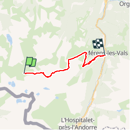

Length
18.3 km

Max alt
2428 m

Uphill gradient
605 m
Km-Effort
30 km

Min alt
1060 m

Downhill gradient
1736 m
Boucle
No
Creation date :
2014-12-10 00:00:00.0
Updated on :
2014-12-10 00:00:00.0
7h41
Difficulty : Difficult

FREE GPS app for hiking
 SityTrail
IGN / Geographical institutes
SityTrail Plus
The world is yours!
About
Trail Walking of 18.3 km to be discovered at Occitania, Ariège, Aston. This trail is proposed by xav34830.
Positioning
Country:
France
Region :
Occitania
Department/Province :
Ariège
Municipality :
Aston
Location:
Unknown
Start:(Dec)
Start:(UTM)
395533 ; 4721397 (31T) N.
Comments