


cirque de troumousse par heas

cemoi
User
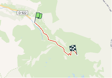

Length
3.2 km

Max alt
2129 m

Uphill gradient
590 m
Km-Effort
9.1 km

Min alt
1532 m

Downhill gradient
4 m
Boucle
No
Creation date :
2019-06-18 08:26:59.773
Updated on :
2020-04-24 08:02:52.443
--
Difficulty : Medium

FREE GPS app for hiking
 SityTrail
IGN / Geographical institutes
SityTrail Plus
The world is yours!
About
Trail Walking of 3.2 km to be discovered at Occitania, Hautespyrenees, Gavarnie-Gèdre. This trail is proposed by cemoi.
Positioning
Country:
France
Region :
Occitania
Department/Province :
Hautespyrenees
Municipality :
Gavarnie-Gèdre
Location:
Gèdre
Start:(Dec)
Start:(UTM)
261807 ; 4737030 (31T) N.
Comments