


Aziré ATSCAF

olaze
User

Length
9.6 km

Max alt
9 m

Uphill gradient
50 m
Km-Effort
10.3 km

Min alt
0 m

Downhill gradient
51 m
Boucle
Yes
Creation date :
2014-12-10 00:00:00.0
Updated on :
2014-12-10 00:00:00.0
2h41
Difficulty : Easy

FREE GPS app for hiking
 SityTrail
IGN / Geographical institutes
SityTrail Plus
The world is yours!
About
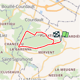
Trail Walking of 9.6 km to be discovered at Pays de la Loire, Vendée, Benet. This trail is proposed by olaze.
Description
Agréable randonnée au départ et retour du port d'Aziré.Dans le marais.Les Nattes, Gué avec bâteau à chaine, canal de Courdault, Ste Christine, rigole d'Aziré.Club rando ATSCAF79 .Juin 2012
Photos


Positioning
Country:
France
Region :
Pays de la Loire
Department/Province :
Vendée
Municipality :
Benet
Location:
Unknown
Start:(Dec)
Start:(UTM)
681503 ; 5137285 (30T) N.
Comments