


2012-06-24 14h59m27

xav34830
User

Length
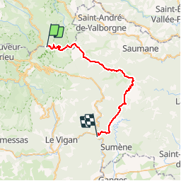
37 km

Max alt
1556 m

Uphill gradient
627 m
Km-Effort
49 km

Min alt
185 m

Downhill gradient
1994 m
Boucle
No
Creation date :
2014-12-10 00:00:00.0
Updated on :
2014-12-10 00:00:00.0
5h34
Difficulty : Unknown

FREE GPS app for hiking
 SityTrail
IGN / Geographical institutes
SityTrail Plus
The world is yours!
About
Trail Other activity of 37 km to be discovered at Occitania, Gard, Val-d'Aigoual. This trail is proposed by xav34830.
Positioning
Country:
France
Region :
Occitania
Department/Province :
Gard
Municipality :
Val-d'Aigoual
Location:
Valleraugue
Start:(Dec)
Start:(UTM)
546359 ; 4885504 (31T) N.
Comments