oulettesde gaube et estom

cemoi
User
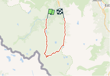

Length
18.3 km

Max alt
2609 m

Uphill gradient
1162 m
Km-Effort
34 km

Min alt
1369 m

Downhill gradient
1262 m
Boucle
No
Creation date :
2019-06-18 08:26:58.87
Updated on :
2020-04-24 08:02:49.823
--
Difficulty : Difficult

FREE GPS app for hiking
 SityTrail
IGN / Geographical institutes
SityTrail Plus
The world is yours!
About
Trail Walking of 18.3 km to be discovered at Occitania, Hautespyrenees, Cauterets. This trail is proposed by cemoi.
Positioning
Country:
France
Region :
Occitania
Department/Province :
Hautespyrenees
Municipality :
Cauterets
Location:
Unknown
Start:(Dec)
Start:(UTM)
733958 ; 4748382 (30T) N.
Comments