


Planhe des belles

mitty
User
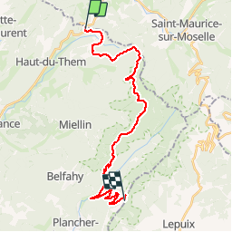

Length
25 km

Max alt
1155 m

Uphill gradient
1081 m
Km-Effort
38 km

Min alt
533 m

Downhill gradient
736 m
Boucle
No
Creation date :
2014-12-10 00:00:00.0
Updated on :
2014-12-10 00:00:00.0
--
Difficulty : Unknown

FREE GPS app for hiking
 SityTrail
IGN / Geographical institutes
SityTrail Plus
The world is yours!
About
Trail Other activity of 25 km to be discovered at Bourgogne-Franche-Comté, Haute-Saône, Haut-du-Them-Château-Lambert. This trail is proposed by mitty.
Positioning
Country:
France
Region :
Bourgogne-Franche-Comté
Department/Province :
Haute-Saône
Municipality :
Haut-du-Them-Château-Lambert
Location:
Unknown
Start:(Dec)
Start:(UTM)
331490 ; 5303158 (32T) N.
Comments