Trail Walking Théoule-sur-Mer - Crêtes des Grues - Théoule - Photo
 tracegps
tracegps

User

© OpenStreetMap contributors
Length
Length
15.1 km
Max alt
Max alt
437 m
Uphill gradient
Uphill gradient
676 m
Km-Effort
Km-Effort  
24 km
Min alt
Min alt
98 m
Downhill gradient
Downhill gradient
676 m
Boucle
Boucle
Yes
Creation date :
2014-12-10 00:00:00.0
Updated on :
2014-12-10 00:00:00.0

(0 Reviews)

Walking
Walking
4h25
Difficulty : Medium

Scan this QR Code to open this trail in the SityTrail application

FREE GPS app for hiking

Logo SityTrail SityTrail

IGN / Geographical institutes

Download SityTrail from the App Store Download SityTrail from Google Play

Logo SityTrail SityTrail World

The world is yours!

Download SityTrail from the App Store Download SityTrail from Google Play Download SityTrail on Huawei AppGallery

About

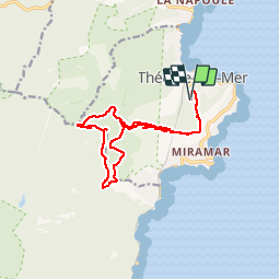
Trail Walking of 15.1 km to be discovered at Provence-Alpes-Côte d'Azur, Maritime Alps, Théoule-sur-Mer. This trail is proposed by tracegps.

Description

Cimetière de Théoule, Notre-Dame d'Afrique, cols de Théoule, du Trayas, de la Cadière, sommets des Grosses Grues et des Petites Grues, col Notre Dame, cols du Trayas et de Théoule.

Elevation profile

Photos

Positioning

Country:
France
Region :
Provence-Alpes-Côte d'Azur
Department/Province :
Maritime Alps
Municipality :
Théoule-sur-Mer
Location:
Unknown
Start:(UTM)
333419 ; 4818497 (32T) N.

Trails nearby

Trail Walking Saint-Raphaël - Massif d'ésterel-grande boucle pic cap roux - Photo
Walking
jeromelacoste

Walking

Medium
(2)
Saint-Raphaël, Provence-Alpes-Côte d'Azur, Var, France
10.4 km | 17.5 km-effort
2h 58min
Yes
Trail Walking Saint-Raphaël - Le tour du Pic du Cap Roux - St Raphaël (Agay) - Photo
Walking
tracegps

Walking

Medium
(2)
Saint-Raphaël, Provence-Alpes-Côte d'Azur, Var, France
7.2 km | 12.8 km-effort
2h 0min
Yes
Trail Walking Saint-Raphaël - Pic du Cap Roux - Photo
Walking
Kilroy06

Walking

Very easy
(4)
Saint-Raphaël, Provence-Alpes-Côte d'Azur, Var, France
4.1 km | 7.8 km-effort
1h 17min
Yes
Trail Walking Mandelieu-la-Napoule - Mont Saint Martin - Photo
Walking
Kilroy06

Walking

Easy
(1)
Mandelieu-la-Napoule, Provence-Alpes-Côte d'Azur, Maritime Alps, France
9 km | 14.2 km-effort
3h 0min
Yes
Trail Walking Saint-Raphaël - Tour du Pic de l'Ours - Le Trayas - Photo
Walking
tracegps

Walking

Medium
(1)
Saint-Raphaël, Provence-Alpes-Côte d'Azur, Var, France
9.5 km | 16 km-effort
3h 0min
Yes
Trail On foot Théoule-sur-Mer - Tracé Rocher des Monges par col de Théoule - Photo
On foot
Sylvie Cagnes

On foot

Very easy
(1)
Théoule-sur-Mer, Provence-Alpes-Côte d'Azur, Maritime Alps, France
7.2 km | 11.2 km-effort
Unknown
Yes
Trail Walking Saint-Raphaël - pic de l'ours pic d' aurelle - Photo
Walking
puchol

Walking

Medium
(2)
Saint-Raphaël, Provence-Alpes-Côte d'Azur, Var, France
10.8 km | 17.7 km-effort
4h 3min
Yes
Trail Walking Théoule-sur-Mer - Théoule - Col de Théoule - ND d'Afrique - Pointe de L'Aiguille - Photo
Walking
LtZIP

Walking

Easy
Théoule-sur-Mer, Provence-Alpes-Côte d'Azur, Maritime Alps, France
9.9 km | 14.9 km-effort
3h 23min
Yes
Trail Walking Saint-Raphaël - PK ND Theoule - Photo
Walking
ETMU5496

Walking

Difficult
Saint-Raphaël, Provence-Alpes-Côte d'Azur, Var, France
18.5 km | 30 km-effort
6h 47min
Yes


Close
My subscriptions