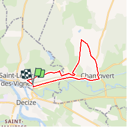
Trail Walking Decize - Decize - Photo
 kronio
kronio

User

© OpenStreetMap contributors
Length
Length
11.4 km
Max alt
Max alt
244 m
Uphill gradient
Uphill gradient
126 m
Km-Effort
Km-Effort  
13.1 km
Min alt
Min alt
187 m
Downhill gradient
Downhill gradient
127 m
Boucle
Boucle
Yes
Creation date :
2014-12-10 00:00:00.0
Updated on :
2014-12-10 00:00:00.0

(1 Reviews)

Walking
Walking
--
Difficulty : Easy

Scan this QR Code to open this trail in the SityTrail application

FREE GPS app for hiking

Logo SityTrail SityTrail

IGN / Geographical institutes

Download SityTrail from the App Store Download SityTrail from Google Play

Logo SityTrail SityTrail Plus

The world is yours!

Download SityTrail from the App Store Download SityTrail from Google Play Download SityTrail on Huawei AppGallery

About

Trail Walking of 11.4 km to be discovered at Bourgogne-Franche-Comté, Nièvre, Decize. This trail is proposed by kronio.

Elevation profile

Points of interest

Point of interest Champvert - D136 et Route - Photo
kronio
CHAMPVERT 
Point of interest Champvert - D205 et Chemin - Photo
kronio
CHAMPVERT 
Point of interest Champvert - Gr3 - Photo
kronio
CHAMPVERT 
Point of interest Saint-Léger-des-Vignes - Gr31 - Photo
kronio
SAINT-LÉGER-DES-VIGNES 
Point of interest Decize - Hauteur de 195 m - Photo
kronio
Point of interest Champvert - Route - Photo
kronio
CHAMPVERT 
Point of interest Champvert - Route et Chemin - Photo
kronio
CHAMPVERT 
Point of interest Champvert - Route et Chemin1 - Photo
kronio
CHAMPVERT 
Point of interest Decize - Route1 - Photo
kronio
DECIZE 

Positioning

Country:
France
Region :
Bourgogne-Franche-Comté
Department/Province :
Nièvre
Municipality :
Decize
Location:
Unknown
Start:(UTM)
535575 ; 5187194 (31T) N.

Comments

Please log in to post a review or rate the element


n ai pas trouve l explication pour enregistrer la rando que j ai faite.


Close
My subscriptions