


Métabief - Le Mont d'Or

bmorel@orange.fr
User
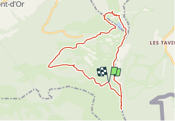

Length
9.6 km

Max alt
1450 m

Uphill gradient
349 m
Km-Effort
14.2 km

Min alt
1191 m

Downhill gradient
353 m
Boucle
Yes
Creation date :
2014-12-10 00:00:00.0
Updated on :
2014-12-10 00:00:00.0
--
Difficulty : Medium

FREE GPS app for hiking
 SityTrail
IGN / Geographical institutes
SityTrail Plus
The world is yours!
About
Trail Walking of 9.6 km to be discovered at Bourgogne-Franche-Comté, Doubs, Longevilles-Mont-d'Or. This trail is proposed by bmorel@orange.fr.
Description
Tracé GPS

Positioning
Country:
France
Region :
Bourgogne-Franche-Comté
Department/Province :
Doubs
Municipality :
Longevilles-Mont-d'Or
Location:
Unknown
Start:(Dec)
Start:(UTM)
297748 ; 5179015 (32T) N.
Comments