roche noire

mikaelerouzic
User
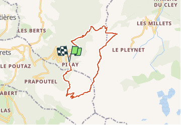

Length
13.7 km

Max alt
2100 m

Uphill gradient
753 m
Km-Effort
24 km

Min alt
1505 m

Downhill gradient
764 m
Boucle
Yes
Creation date :
2014-12-10 00:00:00.0
Updated on :
2014-12-10 00:00:00.0
--
Difficulty : Unknown

FREE GPS app for hiking
 SityTrail
IGN / Geographical institutes
SityTrail Plus
The world is yours!
About
Trail Walking of 13.7 km to be discovered at Auvergne-Rhône-Alpes, Isère, Theys. This trail is proposed by mikaelerouzic.
Positioning
Country:
France
Region :
Auvergne-Rhône-Alpes
Department/Province :
Isère
Municipality :
Theys
Location:
Unknown
Start:(Dec)
Start:(UTM)
265860 ; 5016855 (32T) N.
Comments