


Gruson 14

magnum07
User
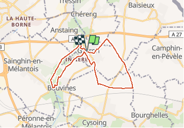

Length
14.1 km

Max alt
54 m

Uphill gradient
80 m
Km-Effort
15.1 km

Min alt
21 m

Downhill gradient
79 m
Boucle
Yes
Creation date :
2014-12-10 00:00:00.0
Updated on :
2020-09-30 16:13:29.714
--
Difficulty : Medium

FREE GPS app for hiking
 SityTrail
IGN / Geographical institutes
SityTrail Plus
The world is yours!
About
Trail Walking of 14.1 km to be discovered at Hauts-de-France, Nord, Gruson. This trail is proposed by magnum07.
Description
Extension des Voyettes du Val de Marque
Positioning
Country:
France
Region :
Hauts-de-France
Department/Province :
Nord
Municipality :
Gruson
Location:
Unknown
Start:(Dec)
Start:(UTM)
514474 ; 5604800 (31U) N.
Comments