Trail Walking Bray-et-Lû - Bray et Lu - Photo
© OpenStreetMap contributors
Length
Length
14.2 km
Max alt
Max alt
149 m
Uphill gradient
Uphill gradient
278 m
Km-Effort
Km-Effort  
17.9 km
Min alt
Min alt
28 m
Downhill gradient
Downhill gradient
277 m
Boucle
Boucle
Yes
Creation date :
2014-12-10 00:00:00.0
Updated on :
2014-12-10 00:00:00.0

(0 Reviews)

Walking
Walking
3h20
Difficulty : Medium

Scan this QR Code to open this trail in the SityTrail application

FREE GPS app for hiking

Logo SityTrail SityTrail

IGN / Geographical institutes

Download SityTrail from the App Store Download SityTrail from Google Play

Logo SityTrail SityTrail World

The world is yours!

Download SityTrail from the App Store Download SityTrail from Google Play Download SityTrail on Huawei AppGallery

About

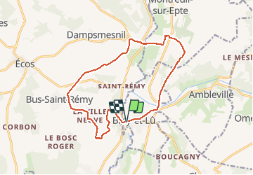
Trail Walking of 14.2 km to be discovered at Ile-de-France, Val-d'Oise, Bray-et-Lû. This trail is proposed by francois911.

Description

Situation:Bray et Lu est à 11km à l'ouest de Magny en Vexin par la D86.
A découvrir en chemin :
. Bray et Lu l'église Notre-Dame XII-XIX°
. Aveny : pont XV°, château XV°
. Baudemont : ruines du chäteau


Elevation profile

Photos

Points of interest

Point of interest Vexin-sur-Epte - Point 1 - Photo
francois911
VEXIN-SUR-EPTE 
Point of interest Vexin-sur-Epte - Point 2 - Photo
francois911
VEXIN-SUR-EPTE 
Point of interest Vexin-sur-Epte - Point 3 - Photo
francois911
VEXIN-SUR-EPTE 
Point of interest Vexin-sur-Epte - Point 4 - Photo
francois911
VEXIN-SUR-EPTE 
Point of interest Vexin-sur-Epte - Point 5 - Photo
francois911
VEXIN-SUR-EPTE 
Point of interest Vexin-sur-Epte - Point 6 - Photo
francois911
VEXIN-SUR-EPTE 
Point of interest Vexin-sur-Epte - Point 7 - Photo
francois911
VEXIN-SUR-EPTE 
Point of interest Vexin-sur-Epte - Point 9 - Photo
francois911
VEXIN-SUR-EPTE 
Point of interest Vexin-sur-Epte - Point 10 - Photo
francois911
VEXIN-SUR-EPTE 
Point of interest Montreuil-sur-Epte - Point 11 - Photo
francois911
MONTREUIL-SUR-EPTE 
Point of interest Montreuil-sur-Epte - Point 12 - Photo
francois911
MONTREUIL-SUR-EPTE 

Positioning

Country:
France
Region :
Ile-de-France
Department/Province :
Val-d'Oise
Municipality :
Bray-et-Lû
Location:
Unknown
Start:(UTM)
401926 ; 5443799 (31U) N.

Trails nearby

Trail Walking Chaussy - Chaussy - Villarceaux vers Chaussy - Photo
Walking
marcel.F

Walking

Easy
(1)
Chaussy, Ile-de-France, Val-d'Oise, France
10.4 km | 12.9 km-effort
2h 48min
Yes
Trail Walking Chaussy - Chaussy - Villarceaux - Genainville - Photo
Walking
marcel.F

Walking

Easy
(1)
Chaussy, Ile-de-France, Val-d'Oise, France
11.3 km | 13.7 km-effort
2h 57min
Yes
Trail Walking Vexin-sur-Epte - Rando Douce 1 - Ecos - Photo
Walking
marcel.F

Walking

Easy
(1)
Vexin-sur-Epte, Normandy, Eure, France
6.5 km | 7.6 km-effort
1h 28min
Yes
Trail Walking Vexin-sur-Epte - Ecos - les trois boucles court - Photo
Walking
marcel.F

Walking

Easy
(2)
Vexin-sur-Epte, Normandy, Eure, France
11.1 km | 13.1 km-effort
2h 51min
Yes
Trail Walking Omerville - omerville et alentours - Photo
Walking
pactometo

Walking

Easy
(3)
Omerville, Ile-de-France, Val-d'Oise, France
12.7 km | 16 km-effort
3h 17min
Yes
Trail Walking Vexin-sur-Epte - Berthenonville Dampsmesni  la côte aux chiens - Photo
Walking
serge.guerroult

Walking

Medium
(1)
Vexin-sur-Epte, Normandy, Eure, France
9.5 km | 12.7 km-effort
2h 16min
Yes
Trail Walking Montreuil-sur-Epte - Montreuil sur Epte La Chapelle en Vexin - Photo
Walking
serge.guerroult

Walking

Difficult
(1)
Montreuil-sur-Epte, Ile-de-France, Val-d'Oise, France
11.1 km | 13.6 km-effort
3h 48min
Yes
Trail Walking Omerville - 180503 - Omerville - Photo
Walking
domelisa78

Walking

Easy
(1)
Omerville, Ile-de-France, Val-d'Oise, France
13.3 km | 17.4 km-effort
3h 21min
Yes
Trail Walking Vexin-sur-Epte - Aveny - Photo
Walking
tbrunet

Walking

Easy
Vexin-sur-Epte, Normandy, Eure, France
7.2 km | 9.2 km-effort
2h 18min
No


Close
My subscriptions