


La Haye du Puits - Mont Castre

mousetik
User
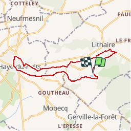

Length
13.1 km

Max alt
123 m

Uphill gradient
183 m
Km-Effort
15.5 km

Min alt
24 m

Downhill gradient
177 m
Boucle
Yes
Creation date :
2014-12-10 00:00:00.0
Updated on :
2014-12-10 00:00:00.0
--
Difficulty : Medium

FREE GPS app for hiking
 SityTrail
IGN / Geographical institutes
SityTrail Plus
The world is yours!
About
Trail Walking of 13.1 km to be discovered at Normandy, Manche, Montsenelle. This trail is proposed by mousetik.
Positioning
Country:
France
Region :
Normandy
Department/Province :
Manche
Municipality :
Montsenelle
Location:
Lithaire
Start:(Dec)
Start:(UTM)
609671 ; 5460547 (30U) N.
Comments