


38 Chartreuse habert d''Arpison

trietsch
User
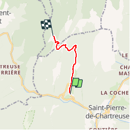

Length
5.3 km

Max alt
1505 m

Uphill gradient
642 m
Km-Effort
11.9 km

Min alt
859 m

Downhill gradient
56 m
Boucle
No
Creation date :
2016-11-01 00:00:00.0
Updated on :
2020-01-04 20:30:57.954
4h00
Difficulty : Medium

FREE GPS app for hiking
 SityTrail
IGN / Geographical institutes
SityTrail Plus
The world is yours!
About
Trail Walking of 5.3 km to be discovered at Auvergne-Rhône-Alpes, Isère, Saint-Pierre-de-Chartreuse. This trail is proposed by trietsch.
Description
depart la correrie
st pierre de chartreuse
Il faut pousser vers le belvédère ( vue magnifique)
Positioning
Country:
France
Region :
Auvergne-Rhône-Alpes
Department/Province :
Isère
Municipality :
Saint-Pierre-de-Chartreuse
Location:
Unknown
Start:(Dec)
Start:(UTM)
718524 ; 5025674 (31T) N.
Comments