


beille

Mipe
User
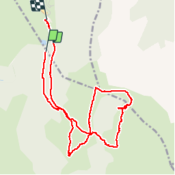

Length
6.4 km

Max alt
1934 m

Uphill gradient
142 m
Km-Effort
8.3 km

Min alt
1790 m

Downhill gradient
158 m
Boucle
No
Creation date :
2014-12-10 00:00:00.0
Updated on :
2014-12-10 00:00:00.0
3h52
Difficulty : Very easy

FREE GPS app for hiking
 SityTrail
IGN / Geographical institutes
SityTrail Plus
The world is yours!
About
Trail Walking of 6.4 km to be discovered at Occitania, Ariège, Aston. This trail is proposed by Mipe.
Description
Rando du 2/08/2012
Photos

Positioning
Country:
France
Region :
Occitania
Department/Province :
Ariège
Municipality :
Aston
Location:
Unknown
Start:(Dec)
Start:(UTM)
392814 ; 4730733 (31T) N.
Comments