


Tellin2

jmvvk
User
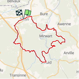

Length
34 km

Max alt
487 m

Uphill gradient
829 m
Km-Effort
45 km

Min alt
243 m

Downhill gradient
836 m
Boucle
Yes
Creation date :
2014-12-10 00:00:00.0
Updated on :
2014-12-10 00:00:00.0
3h28
Difficulty : Medium

FREE GPS app for hiking
 SityTrail
IGN / Geographical institutes
SityTrail Plus
The world is yours!
About
Trail Mountain bike of 34 km to be discovered at Wallonia, Luxembourg, Tellin. This trail is proposed by jmvvk.
Description
Raando
Positioning
Country:
Belgium
Region :
Wallonia
Department/Province :
Luxembourg
Municipality :
Tellin
Location:
Tellin
Start:(Dec)
Start:(UTM)
658487 ; 5549908 (31U) N.
Comments