


2012-08-05 20km Adeps Thuin

R90jd
User
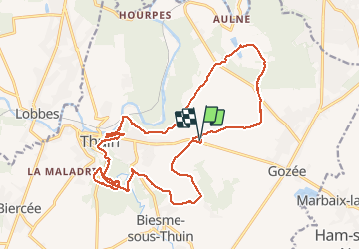

Length
19.8 km

Max alt
208 m

Uphill gradient
370 m
Km-Effort
25 km

Min alt
108 m

Downhill gradient
370 m
Boucle
Yes
Creation date :
2014-12-10 00:00:00.0
Updated on :
2014-12-10 00:00:00.0
3h21
Difficulty : Medium

FREE GPS app for hiking
 SityTrail
IGN / Geographical institutes
SityTrail Plus
The world is yours!
About
Trail Walking of 19.8 km to be discovered at Wallonia, Hainaut, Thuin. This trail is proposed by R90jd.
Photos


Positioning
Country:
Belgium
Region :
Wallonia
Department/Province :
Hainaut
Municipality :
Thuin
Location:
Thuin
Start:(Dec)
Start:(UTM)
594047 ; 5577316 (31U) N.
Comments