


camping oxygène, greoux les bains

francislassauce
User
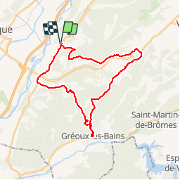

Length
31 km

Max alt
555 m

Uphill gradient
538 m
Km-Effort
38 km

Min alt
288 m

Downhill gradient
537 m
Boucle
Yes
Creation date :
2014-12-10 00:00:00.0
Updated on :
2014-12-10 00:00:00.0
2h07
Difficulty : Medium

FREE GPS app for hiking
 SityTrail
IGN / Geographical institutes
SityTrail Plus
The world is yours!
About
Trail Mountain bike of 31 km to be discovered at Provence-Alpes-Côte d'Azur, Alpes-de-Haute-Provence, Valensole. This trail is proposed by francislassauce.
Description
par ste gregoire


Positioning
Country:
France
Region :
Provence-Alpes-Côte d'Azur
Department/Province :
Alpes-de-Haute-Provence
Municipality :
Valensole
Location:
Unknown
Start:(Dec)
Start:(UTM)
729419 ; 4856218 (31T) N.
Comments