Trail Walking Saint-Aignan - GR41 et bord de Cher quand même possible - Photo

GR41 et bord de Cher quand même possible

© OpenStreetMap contributors
Length
Length
13.4 km
Max alt
Max alt
132 m
Uphill gradient
Uphill gradient
144 m
Km-Effort
Km-Effort  
15.4 km
Min alt
Min alt
63 m
Downhill gradient
Downhill gradient
184 m
Boucle
Boucle
No
Creation date :
2014-12-10 00:00:00.0
Updated on :
2014-12-10 00:00:00.0

(1 Reviews)

Walking
Walking
5h38
Difficulty : Unknown

Scan this QR Code to open this trail in the SityTrail application

FREE GPS app for hiking

Logo SityTrail SityTrail

IGN / Geographical institutes

Download SityTrail from the App Store Download SityTrail from Google Play

Logo SityTrail SityTrail World

The world is yours!

Download SityTrail from the App Store Download SityTrail from Google Play Download SityTrail on Huawei AppGallery

About

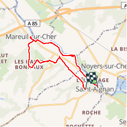
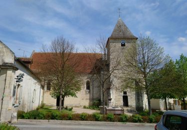
Trail Walking of 13.4 km to be discovered at Centre-Loire Valley, Loir-et-Cher, Saint-Aignan. This trail is proposed by Arnoldr8491.

Description

Petite boucle depuis Saint-Aignan, sur GR41 d'une part (très agréable) et retour depuis Marieul-sur-Cher le long du Cher bien que ne figure par les cartes IGN, absolument praticable. Attention par forts vents, à mon avis risques de d'arbres, probablement la raison pour laquelle non décrite. Dernier km sur Saint-Aignan pas trop sympathique. Une crêpe à la crêperie Au Bigouden au bas de la ville, pourrait arranger les choses..

Elevation profile

Photos

Positioning

Country:
France
Region :
Centre-Loire Valley
Department/Province :
Loir-et-Cher
Municipality :
Saint-Aignan
Location:
Unknown
Start:(UTM)
376479 ; 5236315 (31T) N.

Comments

Please log in to post a review or rate the element


Downloaded the whole of France for 3 types of Maps. Two are NOT working off line. Very frustrating. Will delete this app


Trails nearby

Trail Walking Seigy - Seigy - GR41 Saint-Aignan - 15.3km 250m 3h50 - 2022 08 27 - Photo
Walking
Orcal37

Walking

Easy
Seigy, Centre-Loire Valley, Loir-et-Cher, France
15.3 km | 18.7 km-effort
3h 50min
Yes
Trail Walking Mareuil-sur-Cher - Mareuil-sur-Cher - les Sables GR41 et PR - 15.7km 240m 4h00 - 2022 04 22 - Photo
Walking
Orcal37

Walking

Easy
Mareuil-sur-Cher, Centre-Loire Valley, Loir-et-Cher, France
15.7 km | 18.9 km-effort
4h 0min
Yes
Trail Walking Saint-Aignan - Beauval - 5 km 60m 2h20 - 2017 04 01  - Photo
Walking
Orcal37

Walking

Very easy
Saint-Aignan, Centre-Loire Valley, Loir-et-Cher, France
5 km | 5.8 km-effort
2h 20min
Yes
Trail Walking Saint-Aignan - Saint-Aignan-sur-Cher - Zoo - 2015 12 27 - Photo
Walking
Orcal37

Walking

Very easy
Saint-Aignan, Centre-Loire Valley, Loir-et-Cher, France
13 km | 15.4 km-effort
4h 0min
Yes
Trail Walking Saint-Aignan - Beauval - Photo
Walking
cyberm

Walking

Medium
Saint-Aignan, Centre-Loire Valley, Loir-et-Cher, France
12.1 km | 14.2 km-effort
3h 6min
Yes
Trail Walking Seigy - À côté du GR41 depuis le camping St. Aignan - Photo
Walking
Arnoldr8491

Walking

Very easy
Seigy, Centre-Loire Valley, Loir-et-Cher, France
10.8 km | 12.7 km-effort
5h 50min
No
Trail Walking Châteauvieux - chateau vieux - Photo
Walking
mimilolo

Walking

Medium
Châteauvieux, Centre-Loire Valley, Loir-et-Cher, France
21 km | 24 km-effort
3h 41min
Yes
Trail Walking Mareuil-sur-Cher - Mareuil-sur-Cher - 9.4km 160m 2h25 - 2018 04 01 - Photo
Walking
Orcal37

Walking

Easy
Mareuil-sur-Cher, Centre-Loire Valley, Loir-et-Cher, France
9.4 km | 11.4 km-effort
2h 25min
Yes
Trail Walking Mareuil-sur-Cher - Mareuil-sur-Cher - Gouffre - 13.7km 218m 2h16 - 2017 04 09 - Photo
Walking
Orcal37

Walking

Easy
Mareuil-sur-Cher, Centre-Loire Valley, Loir-et-Cher, France
13.7 km | 16.6 km-effort
2h 15min
Yes


Close
My subscriptions