Trail Walking Ventron - DRUMONT2 - Photo
© OpenStreetMap contributors
Length
Length
9.2 km
Max alt
Max alt
1221 m
Uphill gradient
Uphill gradient
514 m
Km-Effort
Km-Effort  
16.1 km
Min alt
Min alt
868 m
Downhill gradient
Downhill gradient
514 m
Boucle
Boucle
Yes
Creation date :
2018-10-13 05:53:36.694
Updated on :
2018-10-13 05:53:36.704

(0 Reviews)

Walking
Walking
--
Difficulty : Medium

Scan this QR Code to open this trail in the SityTrail application

FREE GPS app for hiking

Logo SityTrail SityTrail

IGN / Geographical institutes

Download SityTrail from the App Store Download SityTrail from Google Play

Logo SityTrail SityTrail Plus

The world is yours!

Download SityTrail from the App Store Download SityTrail from Google Play Download SityTrail on Huawei AppGallery

About

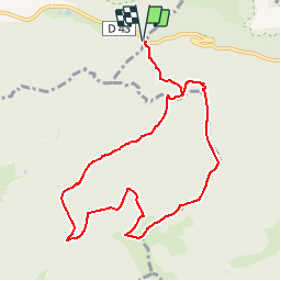
Trail Walking of 9.2 km to be discovered at Grand Est, Vosges, Ventron. This trail is proposed by patrickbeyrath.

Description

Départ parking Col d'Oderen suivre rectangle bleuGR531 direction les DRUMONTS , à la Ferme auberge du Drumontrond jaune vers étang du Drumont jusqu'au Chalet du Plein de repos puis triangle rouge jusqu'au Chalet du Pont Martin et retour Col d'oderen, le tout environ 11km

Elevation profile

Positioning

Country:
France
Region :
Grand Est
Department/Province :
Vosges
Municipality :
Ventron
Location:
Unknown
Start:(UTM)
344387 ; 5309830 (32T) N.


Close
My subscriptions