


Marko baldenheim

legereric
User
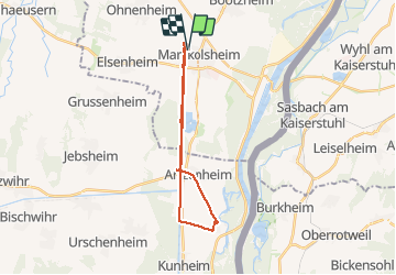

Length
21 km

Max alt
189 m

Uphill gradient
102 m
Km-Effort
22 km

Min alt
172 m

Downhill gradient
102 m
Boucle
Yes
Creation date :
2014-12-10 00:00:00.0
Updated on :
2014-12-10 00:00:00.0
1h16
Difficulty : Easy

FREE GPS app for hiking
 SityTrail
IGN / Geographical institutes
SityTrail Plus
The world is yours!
About
Trail Mountain bike of 21 km to be discovered at Grand Est, Bas-Rhin, Marckolsheim. This trail is proposed by legereric.
Description
Balade vtt
Positioning
Country:
France
Region :
Grand Est
Department/Province :
Bas-Rhin
Municipality :
Marckolsheim
Location:
Unknown
Start:(Dec)
Start:(UTM)
391285 ; 5335912 (32U) N.
Comments