


2ème Jour - 18 Août

jecte
User

Length
69 km

Max alt
124 m

Uphill gradient
479 m
Km-Effort
76 km

Min alt
78 m

Downhill gradient
490 m
Boucle
No
Creation date :
2014-12-10 00:00:00.0
Updated on :
2014-12-10 00:00:00.0
--
Difficulty : Unknown

FREE GPS app for hiking
 SityTrail
IGN / Geographical institutes
SityTrail Plus
The world is yours!
About
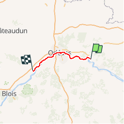
Trail Other activity of 69 km to be discovered at Centre-Loire Valley, Loiret, Germigny-des-Prés. This trail is proposed by jecte.
Description
Chateauneuf sur Loire - Beaugency
Positioning
Country:
France
Region :
Centre-Loire Valley
Department/Province :
Loiret
Municipality :
Germigny-des-Prés
Location:
Unknown
Start:(Dec)
Start:(UTM)
444842 ; 5299560 (31T) N.
Comments