


Aigladines -Col d Uglas -plateau

jeanjacques13
User
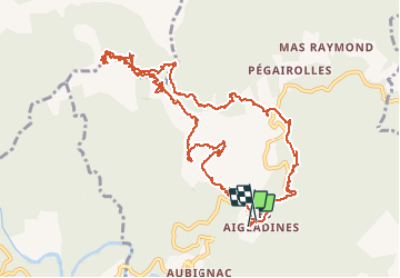

Length
14.9 km

Max alt
629 m

Uphill gradient
495 m
Km-Effort
21 km

Min alt
365 m

Downhill gradient
490 m
Boucle
Yes
Creation date :
2014-12-10 00:00:00.0
Updated on :
2014-12-10 00:00:00.0
4h21
Difficulty : Difficult

FREE GPS app for hiking
 SityTrail
IGN / Geographical institutes
SityTrail Plus
The world is yours!
About
Trail Walking of 14.9 km to be discovered at Occitania, Gard, Mialet. This trail is proposed by jeanjacques13.


Positioning
Country:
France
Region :
Occitania
Department/Province :
Gard
Municipality :
Mialet
Location:
Unknown
Start:(Dec)
Start:(UTM)
573800 ; 4886867 (31T) N.
Comments
Passage de la draille pas facile mais sympas a faire. La petite boucle à mi parcours passe par un chemin pas entretenu.