Trail Running Sainte-Austreberthe - Hivernale du Raid Normand - Photo

Hivernale du Raid Normand

 hgoye
hgoye

User

© OpenStreetMap contributors
Length
Length
48 km
Max alt
Max alt
154 m
Uphill gradient
Uphill gradient
933 m
Km-Effort
Km-Effort  
61 km
Min alt
Min alt
2 m
Downhill gradient
Downhill gradient
1049 m
Boucle
Boucle
No
Creation date :
2014-12-10 00:00:00.0
Updated on :
2014-12-10 00:00:00.0

(0 Reviews)

Running
Running
10h29
Difficulty : Very difficult

Scan this QR Code to open this trail in the SityTrail application

FREE GPS app for hiking

Logo SityTrail SityTrail

IGN / Geographical institutes

Download SityTrail from the App Store Download SityTrail from Google Play

Logo SityTrail SityTrail World

The world is yours!

Download SityTrail from the App Store Download SityTrail from Google Play Download SityTrail on Huawei AppGallery

About

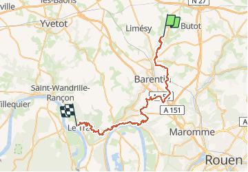
Trail Running of 48 km to be discovered at Normandy, Seine-Maritime, Sainte-Austreberthe. This trail is proposed by hgoye.

Description

Parcours de l'hivernale du RAID Normand 2012. Parcours 42 kilomètres (à la base) qui en fait pas loin de 49 en définitive.

Elevation profile

Points of interest

Point of interest Sainte-Austreberthe - CP 1 - Photo
hgoye
SAINTE-AUSTREBERTHE 
Point of interest Sainte-Austreberthe - CP2 - Photo
hgoye
SAINTE-AUSTREBERTHE 
Point of interest Goupillières - CP 3 - Photo
hgoye
GOUPILLIÈRES 
Point of interest Pavilly - CP 4 - Photo
hgoye
PAVILLY 
Point of interest Pavilly - CP 5 - Photo
hgoye
PAVILLY 
Point of interest Pavilly - CP 6 - Photo
hgoye
PAVILLY 
Point of interest Pavilly - CP 7 - Photo
hgoye
PAVILLY 
Point of interest Pavilly - CP 8 - Photo
hgoye
PAVILLY 
Point of interest Fresquiennes - CP 9 - Photo
hgoye
FRESQUIENNES 
Point of interest Fresquiennes - CP 14 - Photo
hgoye
FRESQUIENNES 
Point of interest Pissy-Pôville - CP 15 - Photo
hgoye
PISSY-PÔVILLE 
Point of interest Pissy-Pôville - CP 16 - Photo
hgoye
PISSY-PÔVILLE 
Point of interest Roumare - CP 17 - Photo
hgoye
ROUMARE 
Point of interest Saint-Pierre-de-Varengeville - CP 18 - Photo
hgoye
SAINT-PIERRE-DE-VARENGEVILLE 
Point of interest Barentin - CP 19 - Photo
hgoye
BARENTIN 
Point of interest Saint-Pierre-de-Varengeville - CP 20 - Photo
hgoye
SAINT-PIERRE-DE-VARENGEVILLE 
Point of interest Saint-Pierre-de-Varengeville - CP 21 - Photo
hgoye
SAINT-PIERRE-DE-VARENGEVILLE 
Point of interest Saint-Pierre-de-Varengeville - CP 22 - Photo
hgoye
SAINT-PIERRE-DE-VARENGEVILLE 
Point of interest Saint-Pierre-de-Varengeville - BIVOUAC - Photo
hgoye
SAINT-PIERRE-DE-VARENGEVILLE 
Point of interest Saint-Pierre-de-Varengeville - CP 1 - Photo
hgoye
SAINT-PIERRE-DE-VARENGEVILLE 
Point of interest Hénouville - CP 4 - Photo
hgoye
HÉNOUVILLE 
Point of interest Saint-Pierre-de-Varengeville - CP 5 - Photo
hgoye
SAINT-PIERRE-DE-VARENGEVILLE 
Point of interest Saint-Pierre-de-Varengeville - CP 6 - Photo
hgoye
SAINT-PIERRE-DE-VARENGEVILLE 
Point of interest Duclair - CP 7 - Photo
hgoye
DUCLAIR 
Point of interest Duclair - CP 8 - Photo
hgoye
DUCLAIR 
Point of interest Duclair - CP 8 bis - Photo
hgoye
DUCLAIR 
Point of interest Le Trait - CP 9 - Photo
hgoye
LE TRAIT 
Point of interest Le Trait - CP 10 - Photo
hgoye
LE TRAIT 
Point of interest Le Trait - CP 14 - Photo
hgoye
LE TRAIT 
Point of interest Le Trait - CP 16 - Photo
hgoye
LE TRAIT 
Point of interest Le Trait - CP 17 - Photo
hgoye
LE TRAIT 
Point of interest Le Trait - CP 26 - Photo
hgoye
LE TRAIT 
Point of interest Le Trait - CP 27 - Photo
hgoye
LE TRAIT 
Point of interest Le Trait - Arrivée - Photo
hgoye
LE TRAIT 

Positioning

Country:
France
Region :
Normandy
Department/Province :
Seine-Maritime
Municipality :
Sainte-Austreberthe
Location:
Unknown
Start:(UTM)
353612 ; 5496163 (31U) N.

Trails nearby

Trail Walking Pavilly - 076-90-Pavilly / St Autreberthe  13.5km - Photo
Walking
rvs147

Walking

Medium
(1)
Pavilly, Normandy, Seine-Maritime, France
12 km | 15 km-effort
3h 23min
Yes
Trail Walking Pavilly - 20220203-Pavilly - Photo
Walking
doudet

Walking

Medium
Pavilly, Normandy, Seine-Maritime, France
12.1 km | 15 km-effort
3h 36min
Yes
Trail Walking Butot - Butot -76- Chemin de randonnée le BOis de Grosfy - Photo
Walking
MichelRando7656

Walking

Difficult
Butot, Normandy, Seine-Maritime, France
14.5 km | 16.7 km-effort
4h 3min
Yes
Trail Walking Pavilly - Pavilly St. Austreberthe (51) - Photo
Walking
randovivi

Walking

Easy
(2)
Pavilly, Normandy, Seine-Maritime, France
10.3 km | 13 km-effort
2h 49min
Yes
Trail Walking Goupillières - Goupillieres 6 - Photo
Walking
francois duparc

Walking

Easy
Goupillières, Normandy, Seine-Maritime, France
6.8 km | 7.6 km-effort
1h 40min
Yes
Trail On foot Hugleville-en-Caux - Le Bois de Grofys - Photo
On foot
PRO

On foot

Easy
Hugleville-en-Caux, Normandy, Seine-Maritime, France
11.6 km | 13.3 km-effort
3h 1min
Yes
Trail On foot Pavilly - 2020-01-22_15h00m10_20200125-pavilly - Photo
On foot
rvs147

On foot

Very easy
Pavilly, Normandy, Seine-Maritime, France
13 km | 16 km-effort
Unknown
Yes
Trail Walking Sainte-Austreberthe - Ste Austreberthe Pavilly A-R - Photo
Walking
MichelARRP

Walking

Difficult
Sainte-Austreberthe, Normandy, Seine-Maritime, France
12.5 km | 15.6 km-effort
3h 7min
Yes
Trail Walking Pavilly - 076-89-Pavilly Ste Austreberthe route du Lin 11km-877-716- - Photo
Walking
rvs147

Walking

Easy
Pavilly, Normandy, Seine-Maritime, France
11 km | 13.7 km-effort
2h 56min
Yes


Close
My subscriptions