Trail Mountain bike Ver-sur-Launette - rando tranquille foret d'Ermenonville - Photo

rando tranquille foret d'Ermenonville

 lafleur
lafleur

User

© OpenStreetMap contributors
Length
Length
16.7 km
Max alt
Max alt
129 m
Uphill gradient
Uphill gradient
168 m
Km-Effort
Km-Effort  
19 km
Min alt
Min alt
77 m
Downhill gradient
Downhill gradient
171 m
Boucle
Boucle
Yes
Creation date :
2014-12-10 00:00:00.0
Updated on :
2014-12-10 00:00:00.0

(0 Reviews)

Mountain bike
Mountain bike
1h29
Difficulty : Easy

Scan this QR Code to open this trail in the SityTrail application

FREE GPS app for hiking

Logo SityTrail SityTrail

IGN / Geographical institutes

Download SityTrail from the App Store Download SityTrail from Google Play

Logo SityTrail SityTrail World

The world is yours!

Download SityTrail from the App Store Download SityTrail from Google Play Download SityTrail on Huawei AppGallery

About

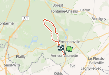
Trail Mountain bike of 16.7 km to be discovered at Hauts-de-France, Oise, Ver-sur-Launette. This trail is proposed by lafleur.

Description


       depart Ver sur launette, rando en vtt facile, avec quand meme un peu de sable, mais vraiment limitée

Elevation profile

Positioning

Country:
France
Region :
Hauts-de-France
Department/Province :
Oise
Municipality :
Ver-sur-Launette
Location:
Unknown
Start:(UTM)
477052 ; 5439190 (31U) N.

Trails nearby

Trail Walking Ermenonville - SM_ERMENONVILLE CHATEAU_NORD_8.1Km - Photo
Walking
GR77LP

Walking

Easy
(1)
Ermenonville, Hauts-de-France, Oise, France
8.1 km | 9.5 km-effort
2h 12min
Yes
Trail Walking Fontaine-Chaalis - Abbaye de Chaalis+fiche+GPX_ 7,8Km_SM - Photo
Walking

Walking

Medium
(8)
Fontaine-Chaalis, Hauts-de-France, Oise, France
7.9 km | 9 km-effort
2h 2min
Yes
Trail Walking Ver-sur-Launette - SM_VER-sur-LAUNETTE_8.5Km - Photo
Walking
GR77LP

Walking

Medium
(7)
Ver-sur-Launette, Hauts-de-France, Oise, France
8.5 km | 9.6 km-effort
2h 6min
Yes
Trail Walking Fontaine-Chaalis - Abbaye de Chaalis Supermini Rando - Photo
Walking

Walking

Medium
(6)
Fontaine-Chaalis, Hauts-de-France, Oise, France
8.5 km | 9.5 km-effort
1h 56min
Yes
Trail Walking Ermenonville - Ermenonville Chateau 6,3 Km - Photo
Walking
GR77LP

Walking

Medium
(4)
Ermenonville, Hauts-de-France, Oise, France
5.8 km | 6.8 km-effort
1h 32min
Yes
Trail Walking Montagny-Sainte-Félicité - SM_MONTAGNY_Ste-FELECITE_8.5Km - Photo
Walking
GR77LP

Walking

Medium
(6)
Montagny-Sainte-Félicité, Hauts-de-France, Oise, France
8.6 km | 10.1 km-effort
2h 12min
Yes
Trail Walking Ver-sur-Launette - SM_LOISY_8.5Km - Photo
Walking
GR77LP

Walking

Medium
(2)
Ver-sur-Launette, Hauts-de-France, Oise, France
8.7 km | 9.7 km-effort
2h 12min
Yes
Trail Walking Othis - SM_BEAUMARCHAIS_8.2Km - Photo
Walking
GR77LP

Walking

Medium
(4)
Othis, Ile-de-France, Seine-et-Marne, France
8.3 km | 9.1 km-effort
2h 3min
Yes
Trail Walking Fontaine-Chaalis - SM_ERMENONVILLE_CROIX-NEUVE_7.9Km - Photo
Walking
GR77LP

Walking

Medium
(6)
Fontaine-Chaalis, Hauts-de-France, Oise, France
7.3 km | 8.3 km-effort
1h 58min
Yes


Close
My subscriptions