


Rifugio Vallanta - Refuge Agnel

i20
User
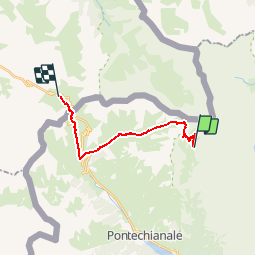

Length
14.5 km

Max alt
2869 m

Uphill gradient
1192 m
Km-Effort
30 km

Min alt
2030 m

Downhill gradient
1055 m
Boucle
No
Creation date :
2014-12-10 00:00:00.0
Updated on :
2014-12-10 00:00:00.0
5h50
Difficulty : Medium

FREE GPS app for hiking
 SityTrail
IGN / Geographical institutes
SityTrail Plus
The world is yours!
About
Trail Walking of 14.5 km to be discovered at Piemont, Cuneo, Pontechianale. This trail is proposed by i20.
Positioning
Country:
Italy
Region :
Piemont
Department/Province :
Cuneo
Municipality :
Pontechianale
Location:
Unknown
Start:(Dec)
Start:(UTM)
346560 ; 4947661 (32T) N.
Comments