


Tour des Fiz

Manujura
User
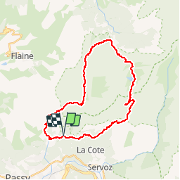

Length
31 km

Max alt
2350 m

Uphill gradient
2185 m
Km-Effort
60 km

Min alt
1231 m

Downhill gradient
2181 m
Boucle
Yes
Creation date :
2014-12-10 00:00:00.0
Updated on :
2014-12-10 00:00:00.0
13h00
Difficulty : Medium

FREE GPS app for hiking
 SityTrail
IGN / Geographical institutes
SityTrail Plus
The world is yours!
About
Trail Walking of 31 km to be discovered at Auvergne-Rhône-Alpes, Upper Savoy, Passy. This trail is proposed by Manujura.
Description
Tour des Fiz en 2 jours avec arrêt au refuge de Sales
Positioning
Country:
France
Region :
Auvergne-Rhône-Alpes
Department/Province :
Upper Savoy
Municipality :
Passy
Location:
Unknown
Start:(Dec)
Start:(UTM)
324205 ; 5091243 (32T) N.
Comments