Trail Mountain bike Draguignan - 
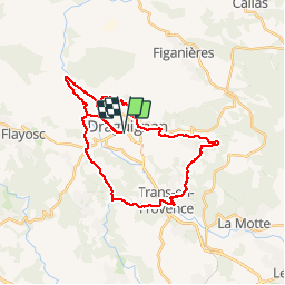
Périphs Dragui-Trans - Photo
 Sugg
Sugg

User

© OpenStreetMap contributors
Length
Length
36 km
Max alt
Max alt
298 m
Uphill gradient
Uphill gradient
546 m
Km-Effort
Km-Effort  
43 km
Min alt
Min alt
136 m
Downhill gradient
Downhill gradient
550 m
Boucle
Boucle
Yes
Creation date :
2019-03-22 17:00:27.22
Updated on :
2019-03-22 17:00:27.311

(0 Reviews)

Mountain bike
Mountain bike
2h34
Difficulty : Medium

Scan this QR Code to open this trail in the SityTrail application

FREE GPS app for hiking

Logo SityTrail SityTrail

IGN / Geographical institutes

Download SityTrail from the App Store Download SityTrail from Google Play

Logo SityTrail SityTrail Plus

The world is yours!

Download SityTrail from the App Store Download SityTrail from Google Play Download SityTrail on Huawei AppGallery

About

Trail Mountain bike of 36 km to be discovered at Provence-Alpes-Côte d'Azur, Var, Draguignan. This trail is proposed by Sugg.

Description

Vtt, peut se faire en VTC, un seul passage sur une piste en terre, beaucoup de passages à l'ombre, quelques belles bosses,belle " balade ".
Ps : la boucle pont d'Aups, pont de la Clappe D955 est faite 2 fois, 1 fois à l'aller et la 2ème au retour.

Elevation profile

Positioning

Country:
France
Region :
Provence-Alpes-Côte d'Azur
Department/Province :
Var
Municipality :
Draguignan
Location:
Unknown
Start:(UTM)
294824 ; 4823306 (32T) N.


Close
My subscriptions