


Grand-Charmont - Bavilliers A/R

ballet
User
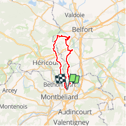

Length
34 km

Max alt
465 m

Uphill gradient
611 m
Km-Effort
42 km

Min alt
324 m

Downhill gradient
614 m
Boucle
Yes
Creation date :
2014-12-10 00:00:00.0
Updated on :
2014-12-10 00:00:00.0
7h00
Difficulty : Difficult

FREE GPS app for hiking
 SityTrail
IGN / Geographical institutes
SityTrail Plus
The world is yours!
About
Trail Walking of 34 km to be discovered at Bourgogne-Franche-Comté, Doubs, Grand-Charmont. This trail is proposed by ballet.
Description
En sous-bois ce tracé passe à proximité de nombreux anciens forts


Positioning
Country:
France
Region :
Bourgogne-Franche-Comté
Department/Province :
Doubs
Municipality :
Grand-Charmont
Location:
Unknown
Start:(Dec)
Start:(UTM)
335987 ; 5265678 (32T) N.
Comments