


Plancher les Mines

ballet
User
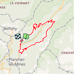

Length
15.5 km

Max alt
903 m

Uphill gradient
781 m
Km-Effort
26 km

Min alt
497 m

Downhill gradient
783 m
Boucle
Yes
Creation date :
2014-12-10 00:00:00.0
Updated on :
2014-12-10 00:00:00.0
3h30
Difficulty : Medium

FREE GPS app for hiking
 SityTrail
IGN / Geographical institutes
SityTrail Plus
The world is yours!
About
Trail Walking of 15.5 km to be discovered at Bourgogne-Franche-Comté, Haute-Saône, Plancher-les-Mines. This trail is proposed by ballet.
Description
Plancher les Mines 15,5km 950m
Cascades de la goutte des saules, grotte St-Antoine, Croix du Choléra, anciens puits de mines
Positioning
Country:
France
Region :
Bourgogne-Franche-Comté
Department/Province :
Haute-Saône
Municipality :
Plancher-les-Mines
Location:
Unknown
Start:(Dec)
Start:(UTM)
331135 ; 5293480 (32T) N.
Comments