Trail Walking Boissy-sous-Saint-Yon - Carrière de Madagascar  - Photo
 danbott
danbott

User

© OpenStreetMap contributors
Length
Length
13.2 km
Max alt
Max alt
158 m
Uphill gradient
Uphill gradient
247 m
Km-Effort
Km-Effort  
16.5 km
Min alt
Min alt
62 m
Downhill gradient
Downhill gradient
252 m
Boucle
Boucle
Yes
Creation date :
2014-12-10 00:00:00.0
Updated on :
2014-12-10 00:00:00.0

(1 Reviews)

Walking
Walking
2h59
Difficulty : Unknown

Scan this QR Code to open this trail in the SityTrail application

FREE GPS app for hiking

Logo SityTrail SityTrail

IGN / Geographical institutes

Download SityTrail from the App Store Download SityTrail from Google Play

Logo SityTrail SityTrail World

The world is yours!

Download SityTrail from the App Store Download SityTrail from Google Play Download SityTrail on Huawei AppGallery

About

Trail Walking of 13.2 km to be discovered at Ile-de-France, Essonne, Boissy-sous-Saint-Yon. This trail is proposed by danbott.

Description

Départ de Boissy

Elevation profile

Positioning

Country:
France
Region :
Ile-de-France
Department/Province :
Essonne
Municipality :
Boissy-sous-Saint-Yon
Location:
Unknown
Start:(UTM)
441676 ; 5377533 (31U) N.

Comments

Please log in to post a review or rate the element


Toute nouvelle sur le site. Assez conviviale à première vue.


Trails nearby

Trail Walking Lardy - Lardy - Chamarande -F - Photo
Walking
nicolas93

Walking

Medium
(2)
Lardy, Ile-de-France, Essonne, France
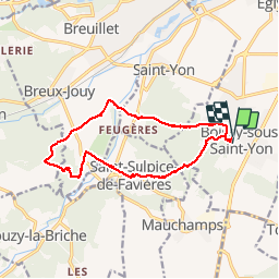
18.3 km | 22 km-effort
4h 44min
Yes
Trail Walking Saint-Sulpice-de-Favières - Les Pétales de Souzy - Photo
Walking
tracegps

Walking

Difficult
(1)
Saint-Sulpice-de-Favières, Ile-de-France, Essonne, France
23 km | 29 km-effort
4h 49min
Yes
Trail Walking Lardy - Autour de Lardy par la Pierre levée de Janville sur Juine - Photo
Walking
tracegps

Walking

Difficult
(1)
Lardy, Ile-de-France, Essonne, France
24 km | 29 km-effort
4h 49min
Yes
Trail On foot Saint-Yon - Sur les traces de la Renarde - Photo
On foot
PRO

On foot

Very difficult
Saint-Yon, Ile-de-France, Essonne, France
38 km | 44 km-effort
10h 4min
No
Trail Walking Saint-Sulpice-de-Favières - St Sulpice - Photo
Walking
Auger91

Walking

Medium
(1)
Saint-Sulpice-de-Favières, Ile-de-France, Essonne, France
8 km | 10.1 km-effort
2h 18min
Yes
Trail On foot Lardy - Boucle Lardy par Pascale - Photo
On foot
chessyca

On foot

Easy
Lardy, Ile-de-France, Essonne, France
20 km | 25 km-effort
5h 36min
Yes
Trail Walking Saint-Sulpice-de-Favières - Saint-Sulpice-de-Favières - Photo
Walking
guydu41

Walking

Medium
Saint-Sulpice-de-Favières, Ile-de-France, Essonne, France
7.5 km | 9.4 km-effort
1h 55min
Yes
Trail Walking Chamarande - Lardy - Le Lièvre d'Or - Photo
Walking
guydu41

Walking

Difficult
Chamarande, Ile-de-France, Essonne, France
9 km | 12.4 km-effort
2h 48min
Yes
Trail Walking Cheptainville - Forêt Régionale de Cheptainville  - Photo
Walking
guydu41

Walking

Easy
Cheptainville, Ile-de-France, Essonne, France
7.2 km | 8.8 km-effort
1h 51min
Yes


Close
My subscriptions