


Hillion

kronio
User

Length
12.8 km

Max alt
43 m

Uphill gradient
162 m
Km-Effort
14.9 km

Min alt
4 m

Downhill gradient
160 m
Boucle
Yes
Creation date :
2014-12-10 00:00:00.0
Updated on :
2014-12-10 00:00:00.0
3h06
Difficulty : Easy

FREE GPS app for hiking
 SityTrail
IGN / Geographical institutes
SityTrail Plus
The world is yours!
About
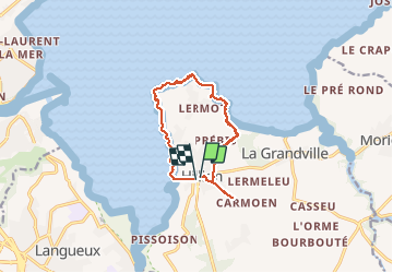
Trail Walking of 12.8 km to be discovered at Brittany, Côtes-d'Armor, Hillion. This trail is proposed by kronio.
Description
Le fond de la baye de saint -brieuc forme une zone humide d’intérêt international et classe réserve naturelle
Positioning
Country:
France
Region :
Brittany
Department/Province :
Côtes-d'Armor
Municipality :
Hillion
Location:
Unknown
Start:(Dec)
Start:(UTM)
524566 ; 5373508 (30U) N.
Comments
Super beau