


la pointe du roselière

kronio
User

Length
8.5 km

Max alt
89 m

Uphill gradient
177 m
Km-Effort
10.9 km

Min alt
11 m

Downhill gradient
181 m
Boucle
Yes
Creation date :
2014-12-10 00:00:00.0
Updated on :
2014-12-10 00:00:00.0
2h40
Difficulty : Easy

FREE GPS app for hiking
 SityTrail
IGN / Geographical institutes
SityTrail Plus
The world is yours!
About
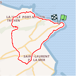
Trail Walking of 8.5 km to be discovered at Brittany, Côtes-d'Armor, Plérin. This trail is proposed by kronio.
Description
Le long du GR34 en suite à l'intérieur des terres
Positioning
Country:
France
Region :
Brittany
Department/Province :
Côtes-d'Armor
Municipality :
Plérin
Location:
Unknown
Start:(Dec)
Start:(UTM)
520941 ; 5377950 (30U) N.
Comments