


Pic du midi

lwathelet
User
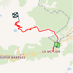

Length
10.6 km

Max alt
2822 m

Uphill gradient
1305 m
Km-Effort
25 km

Min alt
1560 m

Downhill gradient
255 m
Boucle
No
Creation date :
2014-12-10 00:00:00.0
Updated on :
2014-12-10 00:00:00.0
--
Difficulty : Difficult

FREE GPS app for hiking
 SityTrail
IGN / Geographical institutes
SityTrail Plus
The world is yours!
About
Trail Running of 10.6 km to be discovered at Occitania, Hautespyrenees, Bagnères-de-Bigorre. This trail is proposed by lwathelet.
Positioning
Country:
France
Region :
Occitania
Department/Province :
Hautespyrenees
Municipality :
Bagnères-de-Bigorre
Location:
Unknown
Start:(Dec)
Start:(UTM)
269853 ; 4754795 (31T) N.
Comments